Hydrogeological survey is an investigation of soil and rock formations to locate an aquifer, which is a
porous water bearing rock. The survey is done first before drilling a borehole, to identify the best point
to drill, as well as the depth to drill. Any given hydrogeological survey in Kenya has to be conducted by a
professional, and duly registered geologist.
The aim of a borehole drilling project is to get reliable and ample supply of water from the depths of the
Earth. To undertake a borehole drilling project, and come up empty, with a dry borehole, or with a low
yield borehole is a great loss.
Carrying out hydrogeological survey the right way bolsters the chances of success.
Quality and quantity
It is important to note that hydrogeological survey only locates a water bearing rock or an aquifer. The
survey does not provide data on the quality or quantity of water. Geologists can only estimate quantity
and quality using data from nearby boreholes. But sometimes, even these estimations can be wrong due
to differing geological properties.
Essentially, the quantity and quality of water can only be determined with certainty after the borehole
has been drilled and respective tests conducted.
Survey techniques
During hydrogeological survey, different measurement techniques are used to collect data that is used to
prospect for groundwater. All these techniques work in tandem, providing different data which when
interpreted well points to an aquifer.
The most important data collected includes:
- Electrical resistivity
- Soil profile map
The following techniques are used in hydrogeological survey in Kenya:
- Magnetic survey
- Ground scanning with ground penetrating radar (GPR)
- Resistivity survey
- Water dowsing
For each technique, there is a pattern in data collected that indicates the presence or none of an aquifer.
A geologist is guided by these indicators when choosing the recommended drilling point.
The most important data collected includes:
- Electrical resistivity
- Soil profile map int.
The following techniques are used in hydrogeological survey in Kenya:
- Magnetic survey
- Ground scanning with ground penetrating radar (GPR)
- Resistivity survey
- Water dowsing
For each technique, there is a pattern in data collected that indicates the presence or none of an aquifer.
A geologist is guided by these indicators when choosing the recommended drilling point.
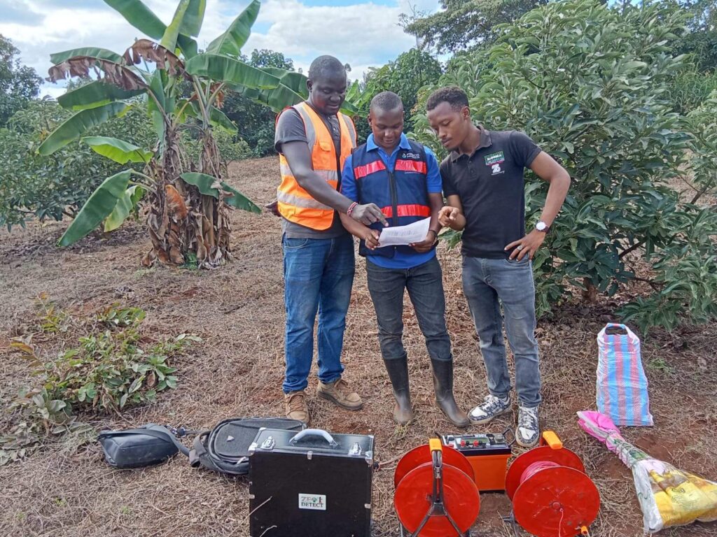
Magnetic Survey
Magentic surveys are done using a hand-held rotating probe, commonly known as the ‘Pool Finder’.
The probe detects variations in the Earth’s magnetic field caused by differences in magnetic properties
of rocks underneath. Anomalies or inconsistencies in magnetic field indicate the presence of distinct
features synonymous with aquifers, such as fractures.
The probe used is capable of measuring the direction of magnetic fields, and it will guide the geologist
towards the spot with perceived groundwater potential.
This method does not detect the presence of groundwater, only the presence of geological features
associated with aquifers. It’s accuracy may also not be exact to the point, compared to other
methods. Therefore, it is advised against relying solely on magnetic survey.
Geologists use magnetic surveys to help them narrow down to areas of substantial groundwater
potential.
Resistivity Survey
Of all the techniques discussed above, this is the only technique that actually detects the presence of
water bearing rocks.
Resistivity survey is also the oldest technique in the book, meaning it is tried, tested and proven.
The technique works by measuring electrical resistivity of the soil profile of different points along a
predetermined axis.
Electrical resistivity in this regard is a measure of how easily electric current moves through the ground.
Water is a good conductor of electricity, and has a low resistivity. Formations with aquifers will have
low resistivity, while those with dry, impermeable zones will have high resistivity.
The pattern of change in resistivity, among other patterns informs on the depth to drill. A spike in
resistivity is indicative of an impending hard rock that is difficult to penetrate. If resistivity increases
steadily without a spike, it indicates that the hard basement rock has not been reached yet.
A geologist must be competent enough to interpret resistivity readings, and draw accurate inferences.
Survey report
After the survey, a report is compiled by the geologist, with the data gathered on different points, its
interpretation, the best point and depth to drill.
This report is afterwards submitted to the Water Resources Authority (WRA), which issues an
authorizarion to drill a borehole.
Cost
The cost of hydrogeological survey in Kenya ranges between KES 45,000 and 50,000 depending on the
location. Other costs one must consider include:
- WRA Permit – KES 30,000
- NEMA Permit – KES 30,000
- County Government Charges
- Water Supplier, like NWSC – Letter of No Objection